How Will South America Fare During the Next Cataclysm?
A geophysical risk analysis for preppers
There are a couple of very good reasons why someone would look to the Southern Hemisphere for a place of refuge during these tumultuous times. Approximately 87% of the world’s population lives in the Northern Hemisphere. The Northern Hemisphere hosts the top military powers of the world. With a reckless and aggressive foreign policy, the United States government, Israel and NATO are risking global war. Very few countries in the Southern Hemisphere engage in global conflicts and their governments tend to be more sensible when it comes to relations with other nations. The Southern Hemisphere is not likely to be a direct target for nuclear war.
The other strong reason to consider the Southern Hemisphere is that there is generally less affluence and a higher level of food self-sufficiency in the Global South. Because the Southern Hemisphere is predominantly made up of “developing” economies, the populations have much less far to fall during a global collapse. A population living closer to subsistence in the present will have more of the skills necessary for resilience during a cataclysm.
In the Southern Hemisphere there is Southern Africa, Oceania and South America. Oceania is generally undesirable due to earthquake, volcanic, and low elevation risks. Additionally, while New Zealand and Australia may once have been desirable locations to live, they are no longer so. Censorship and other attacks on freedom, NATO friendly partnerships, digital identity, government response to alleged pandemics, etc. have made these two countries undesirable. South America has a higher Human Development Index (health/longevity, education, and income) than Africa, so the quality of life is considered better. The harshness of poverty is generally less extreme in South America. Africa also has much less high elevation mountain options than South America. South America is likely the best that the Southern Hemisphere has to offer as a sanctuary.
Elevation
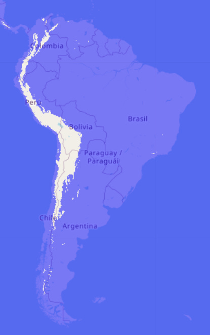
The first consideration should be elevation. For reasons that I will get into in a future article I believe that there is compelling geophysical evidence that prior ocean intrusions onto the land reached about a mile high in elevation up to the Rocky Mountains in the center of the North American continent. If we use the elevation of the former Bonneville Lake shoreline within the Great Basin as a guide, we can surmise a similar tsunami height to have affected other continents during the Great Floods of the past. In the map below, the area of the Andes Mountain range in white is above 1 mile in elevation (1600 meters).
Northern Argentina and Chile, Bolivia, Peru, Ecuador, Colombia, and a small section of Venezuela all have high Andes Mountains running through them. Because the Andes mountains are much closer to the ocean than the Rocky Mountains I think it is prudent to be much higher in elevation than just 1 mile. In the map below I set the water level to 2500 meters. The white areas below are the first areas to consider for settlement, in preparation for a global cataclysm.
Reading Chapter 11, The Evidence Of Violent Extinction In South America, pages 312 - 329 in Charles Hapgood's book, The Path of the Pole, (← free download) the authors, J. B. Delair and E. F. Oppé, make a compelling case that a cataclysmic event wiped out much of the South American mega-fauna.
Page 319:
“Burmeister says, ‘the diluvial deposit containing bones of animals of this age extends over the whole Brazilian plain, from the flanks of the Cordilleras to the borders of the Atlantic.’ They have also been found abundantly in Bolivia on the great plateau; and also west of the mountains both in Peru and Chile.
From Caracas [Venezuela] in the north, to the sierra of Tandel in Patagonia in the south, they have, in fact, occurred in more or less abundance over the whole continent.
In the great Argentine plain they are found close to the sea-level, while in Bolivia they occur, according to D’Orbigny, at a height of 4000 meters, and they are found with a singular similarity if not uniformity of contents in all latitudes.
That the surface beds of the Pampas and the deposits in the caves were synchronous, is admitted by all explorers. The same creatures are found in both, of course in different proportions, as is the case elsewhere.
Nor is there any doubt that both sets of beds date from the same horizon as the Mammoth beds of other countries.
The fauna of the Pleistocene beds of the Southern States of North America is, in fact, largely identical with that from the beds we are now discussing; the megatherium and mylodon, the tapir and capybara, the mastodon and horse, etc., etc.; being found in both, and every observer, from Darwin to Burmeister, is agreed in assigning them to the same horizon (29:325-6).
Evidence of extinction indicates that a great tsunami was in part responsible for the mass die off event(s). Dr. C. D. Meigs wrote a report about a discovery along the banks of the river Santas in Brazil , page 321:
“Captain Elliot, while riding along the banks of the river Santas on his way from the port of Santas to the town of St. Paul, found a mound three acres in extent and 14 feet high, about 10 miles from the sea and 4 from Santas.
The bones he took with him to America . . . were dug from the face of the hill, where it was cut by the wash of the stream, and are parts of one skeleton out of many hundreds that are still lying in their bed of tufa.
They were lying on the rock in an oblique direction, the heads uppermost, and the lower extremities dipping at an angle of from 20° to 25° below the horizon.
Portions of the bones were invested externally with a stalactitic deposit of carbonate of lime, looking very much like a mummified skin. Close to one of the teeth was a serpula and a piece of oyster-shell. The rock in which the skeleton was embedded consisted of fragments of shells united by a stalactitic matter, and contained nodules of carbonaceous matter. . . .
A question naturally arises as to the date of that catastrophe which enclosed several hundred individuals in that tufa of the Rio Santas. . . .
It seems unlikely that these remains were formally buried by sorrowing friends. It is unlikely that so solid a stone should have been formed at so great a distance from the sea. . . . No doubt they are co-existent with the emerged land; they are not to be considered as the results of human industry.
The shore of the Atlantic must have formerly swept nearly in a line with these remarkable deposits. . . . Within this bed, or nearer than it to the sea, are found fossil bones of elephants, etc., which cannot be so old as the unfossilized oyster-shells, since they could not have been fossilized anterior to the existence of the soil out of which they are dug, unless you consider them as boulders, which is inadmissible. . . . (29:355-6).”
Page 322:
“In a limestone cavern on the borders of the Lagoa do Sumidouro, some three leagues from Santa Lucia, Dr. P. W. Lund excavated the bones of more than thirty individuals (human) of both sexes and various ages. The skeletons lay buried in hard clay overlying the original red soil forming the floor of the cave and were found mixed together in such great confusion—not only with one another but with the remains of the Megatherium and other Pleistocene mammals—as to preclude the idea that they had been entombed by the hand of man. All the bones, whether human or animal, showed evidence of having been contemporary with one another.
In other caves investigated by Lund, bones of ancient men were found alongside those of the formidable Smilodon, a giant feline which became extinct during the last Pleistocene times. Referring to the evidence from these and other Brazilian fossiliferous caves, the Marquis de Nadaillac wrote:
‘. . . Doubtless these men and animals lived together and perished together, common victims of catastrophes, the time and cause of which are alike unknown (42:25).”
Page 323:
“Darwin observed, in Voyage of the Beagle (1876 edition), that some remains of a large unknown mammal exhumed from Pleistocene deposits in the Banda Oriental district of Uruguay appeared so fresh that:
‘... it is difficult to believe that they have lain buried for ages underground. The bone contains so much animal matter, that when heated in the flame of a spirit-lamp it not only exhales a very strong animal odour, but likewise burns with a slight flame (op. cit., iii, 181).’
Fossil bones when subjected to heat or fire do not ordinarily burn with a flame. Elsewhere Darwin referred to the perfect preservation of even the minutest details of fossil bones dug up at Bahia Blanca. In his description of the skeleton of the giant sloth Mylodon, Professor Richard Owen noted a similarly perfect state of preservation as regards the individual bones and concluded that the individual represented must have been buried almost immediately upon death.”
Page 324:
“From the extensive literature on the subject it is impracticable here either to acknowledge further sources or to extract the many additional examples known of similar burials. Special reference, however, should be made to the undermentioned specimens derived from the Pampas areas, which suggest flood action:
a. Mammalian skeletons in natural, or upright, positions. These are embedded respectively in undisturbed and largely unstratified beds of gravel, loam, or mud.
b. A skeleton of an adult female Mylodon found in a natural posture alongside that of its young one embedded in gravel…
Included in this category are the discoveries in the La Pumilla Valley of the carapaces of giant armadillos standing upright on their edges in the Pampas mud (8:ii,85). Burmeister, who noted these occurrences, also mentioned that the cuirasses of the great glyptodonts are generally found reversed, and that many instances are known of large, though usually incomplete, mammalian skeletons being found upside down, or with their bones manifestly disjointed and scattered within a small space (ibid.).
These extraordinary modes of burial are further exemplified by the groups or caches of animal fossils unearthed at widely separated South American localities, in which incongruous animal types (carnivores and herbivores) are mixed promiscuously with human bones. These are found not only in the Pampas formation but also in Brazilian caves and in volcanic ash at Punin [Ecuador] and elsewhere. No less significant is the association—over truly widespread areas—of fossilized land and sea creatures mingled in no order and yet entombed in the same geological horizon, and also the occurrence of mastodon remains in the Cordilleras at altitudes impossibly high for their ordinary existence. Clearly these varied, but apparently contemporaneous, burials all over the South American continent are the results of different and relatively localized effects of a single tremendous upheaval, the numerous ramifications of which operated synchronously. In seeking to explain one of these effects, one must explain them all.”
Pages 325-326:
“The reader will not fail to be impressed by the conclusions reached by Alcide d’Orbigny, to whose standing and accuracy tribute must still be paid; he wrote:
‘It would seem that one cause destroyed the terrestrial animals of South America, and that this cause is to be found in great dislocations of the ground caused by the upheaval of the Cordilleras.
If not, it is difficult to conceive on the one hand the sudden and fortuitous destruction of the great animals which inhabited the American continents, and on the other the vast deposit of Pampan mud.
I argue that this destruction was caused by an invasion of the continent by water, a view which is completely en rapport with the facts presented by the great Pampan deposit, which was clearly laid down by water.
How otherwise can we account for this complete destruction and the homogeneity of the Pampas deposits containing bones? I find an evident proof of this in the immense number of bones and of entire animals whose numbers are greatest at the outlets of the valleys, as Mr. Darwin shows.
He found the greatest number of the remains at Bahia Blanca, at Bajada, also on the coast, and on affluents of the Rio Negro, also at the outlet of the valley. This proves that the animals were floated, and hence were chiefly carried to the coast.
This hypothesis necessitates that the Pampas mud was deposited suddenly as the result of violent floods of water, which carried off the soil and other superfluous debris, and mingled them together. This homogeneity of the soil in all parts of the Pampas, even in places 200 leagues apart, is very remarkable.
These are not different strata differently coloured, but a homogeneous mass, which is more or less porous, and shows no signs of distinct stratification. The deposit is also of one uniform colour, as if it had been mixed in one muddy flood slightly tinted by oxide of iron.
The bones, again, are only found isolated in the lower strata, while entire animals occur on the circumference or the upper part of the basin. Thus they are very rare at Buenos Aires, while they abound in the Banda Oriental and in the White Bay. Mr. Darwin says they are heaped up in the latter place, which again supports the contention.
Another argument may be drawn from the fact that the Pampas mud is identical in colour and appearance with the earth in which the fossil remains occur in the caverns and fissures of Minaes Geraes in Brazil, and the fragments brought by M. Claussen are completely like the others in colour and texture.
My final conclusion from the geological facts I have observed in America is, that there was a perfect coincidence between the upheaval of the Cordilleras, the destruction of the great race of animals, and the great deposit of Pampas mud.’ (21 :iii, 3, 82, 85, 86).”
The evidence seems to indicate that a giant tsunami passing over South America, in combination with a massive uplifting of the Andes Mountain range, wiped out humans and animals alike. When do huge earth movements and Great Floods coincide? During a Cataclysm.
So the only areas that are worth considering for settlement in South America are high elevation areas in the Andes with a (relatively) lower risk of earthquakes and volcanoes.
Volcanoes
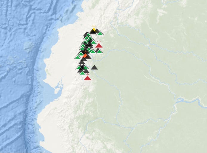
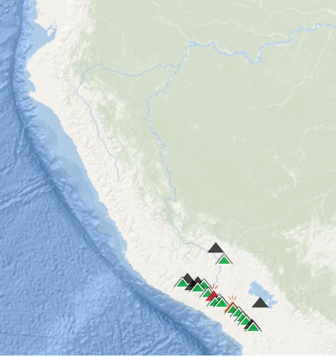
The volcanoes are concentrated along the Andes Mountain Range in South America.

The color coding of the different volcanoes (the triangle icons) are: red (erupting), orange (warning), yellow (unrest), green (dormant) and black (believed to be extinct).
There are only three zones in the Andes without volcanoes: a small section in northern Colombia/Venezuela, a bigger gap in the volcanic arc in northern Chile/Argentina, and the largest gap in northern Peru reaching up into southern Ecuador.
How far should you be from the nearest volcanic zone? As far as possible.
“Knowledge about past eruptions of Yellowstone combined with mathematical models of volcanic ash dispersion help scientists determine where and how much ashfall will occur in possible future eruptions. During the three caldera-forming eruptions that occurred between 2.1 million and 640,000 years ago, tiny particles of volcanic ash covered much of the western half of North America. That ash was likely a third of a meter deep several hundred kilometers from Yellowstone and several centimeters deep farther away.” (Source)
During cataclysms new volcanic zones will emerge. In the case of a super volcano, the radius of destruction could be hundreds of kilometers/miles.

“Eruptions of the Yellowstone volcanic system have included the two largest volcanic eruptions in North America in the past few million years; the third largest was at Long Valley in California and produced the Bishop ash bed. The biggest of the Yellowstone eruptions occurred 2.1 million years ago, depositing the Huckleberry Ridge ash bed. These eruptions left behind huge volcanic depressions called "calderas" and spread volcanic ash over large parts of North America (see map). If another large caldera-forming eruption were to occur at Yellowstone, its effects would be worldwide. Thick ash deposits would bury vast areas of the United States, and injection of huge volumes of volcanic gases into the atmosphere could drastically affect global climate.” (Source)
Colombia
Columbia is eliminated from consideration on 2 counts.
The proximity of the volcanic zones to the high elevation areas.

The high elevation mountains that are the farthest from the ocean host the nation’s capital city of Bogotá. During cataclysms people will flood out of population centers (cities) and ravage the surrounding countryside of its resources and people.
In addition to volcanoes, the incursion of oceans onto the land must also be considered. Here is the flood map for Colombia:
Venezuela
Venezuela’s high ground looks a little better in terms of distance from volcanic risks, but it is closer to the ocean. The mountains furthest from the sea have the large population center of Merida at 1600 meters (1 mile) in elevation. I slightly favor Venezuela over Colombia in terms of geophysical risk but the current Venezuelan authoritarian government precludes that country from consideration. The other two gaps (Peru/Ecuador and Chile/Argentina) in the South American line of volcanoes offer much better prospects for survival.
Earthquakes
This is a map of high risk Earthquake areas (areas in red). As you can see, the Andes mountains in South America is considered a high seismic risk. (Image Source: Top Earthquake Risks in the Pole Shift)
There is evidence that the Andes were lifted up several thousand meters in elevation during a prior cataclysm(s). The evidence for this is covered in Chapter 11, The Evidence Of Violent Extinction In South America, pages 312 - 329 in Charles Hapgood's book, The Path of the Pole. The evidence includes:
In the heart of the Andes from Lake Titicaca in Peru south to Argentina at an average elevation of 12,300 feet (3,750 meters), extends the highest lacustrine basin in the world, the Meseta or Altiplano, on the floor of which occurs a succession of remarkable lakes and salt flats. There are several species of marine life in these landlocked lakes.
Several of these lakes and salt-beds have chemical compositions similar
to that of the ocean.
A few miles south of Lake Titicaca lies the celebrated ruin site of Tiahuanaco. The metropolis possesses an ocean waterfront. This assertion rests upon discernible traces of alkaline incrustations on the sides of the huge stone blocks forming a harbor-basin, or canal wall. The line of these incrustations corresponds closely with that of a strand-line on the slopes of the surrounding mountains.
A clear strand line marked indicates a former coast line:
“The strand-line ... is very distinct. It consists not only of notches cut into the rock by the prolonged action of shore waves, and of fanlike delta deposits of mud and gravel which former streams dropped on meeting the ancient water’s edge, but chiefly of conspicuous deposits of white lime, of a thickness of many feet, upon the red sandstone, or brown porphyry and amorphous slate, or grey granite and andesite. This white streak, which is drawn along the slopes of the mountain chains surrounding the Altiplano, and visible on the islands of Lake Titicaca like a chalk-line, is the residue of certain calcareous algae, chiefly of alga characea.” (The Path of the Pole, page 317)
This strand line has been carefully surveyed by multiple parties for a distance of 375 miles until it becomes lost in the Salt Desert of Uyuni some 12,300
feet above sea-level.
Ancient agricultural stone terraces surrounding the Titicaca basin. These structures present:
“Remarkable confirmation of the immensity of this uplift… by the ancient agricultural stone terraces surrounding the Titicaca basin. These structures, belonging to some bygone civilization, occur at altitudes far too high to support the growth of crops for which they were originally built. Some rise to 15,000 feet above sea level, or about 2,500 feet above the ruins of Tiahuanaco, and on Mt. Illimani they occur up to 18,400 feet above sea level; that is, above the line of eternal snow (46:39).
Posnansky, who described these terraces as practically endless, concluded that the entire Altiplano region was formerly at a much lower level than at present (46:39). It is clear, however that other areas of the Cordillera underwent profound changes also; Dr. E. Huntington noted from aerial survey photographs of arid and desert regions in Peru: ... an unexpected number of old ruins, and an almost incredible number of terraces for cultivation (30:578), showing how some ancient race had cultivated formerly fertile tracts, now absolutely desiccated.” (The Path of the Pole, pages 317-318)
For the ocean floor to have been thrust up an approximate 3,800 meters in elevation, there must have been absolutely devastating earthquakes.
In addition to reading Hapgood’s book, you can also watch the summary video: When the Land Rose Out of the Sea: Pole Shift
I have heard many stories of land slides destroying houses or houses sliding down a hill in the Sierras of South America, during El Niño. Lots of mud slides were reported to have blocked roads and buried homes.
The amount of rain during these types of cataclysmic events, combined with the seismic activity, will undoubtedly devastate many areas of the Andes.
As you can observe on the maps below, the less seismic zones in the Andes correspond to the gaps of volcanoes.
"Geoscientists agree that a subduction zone offshore of the west coast of South America somehow promotes mountain building in the Andes."
(Source: Study Explores How Tectonic Forces Shape The Andes)
Interestingly, southern Ecuador apparently has its own section that it shares with northern Peru and it is considered less seismic:
"In between these two active segments, the research team identified a third subduction segment. Somewhat surprisingly, this is characterized by sliding that is mainly 'aseismic.' So in this area spanning more than 1,000 km from the north of Peru to the south of Ecuador, or 20% of the length of the Andean subduction..."
(Source: Seismic hazards reassessed in the Andes)
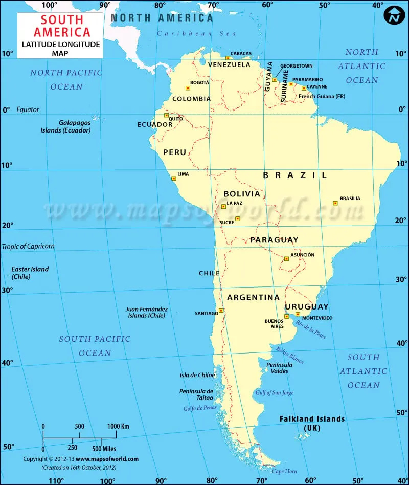
Chile/Argentina
The volcanic gap of northern Chile/Argentina is very arid. On the positive side, no doubt because of the lack of water, the region is also of a low population density.
I would favor the Peruvian volcanic gap in the case that South America shifts southward during the next pole flip. It could be too cold in the volcanic gap of Northern Chile/Argentina. In my article, The Mammoth Conundrum, I make the case that the prior North Pole flip was 30-degrees, from Hudson Bay, Canada to its current position. Should the next flip be a 30-degree or similar move of the North Pole towards Russia, then Chile/Argentina could easily become too cold as they shift toward the current South Pole. Right now the center of the volcanic gap in Argentina/Chile is about 30-degrees latitude from the equator. A 30-degree shift of the continent southward would plunge those countries into freezing temperatures, especially at high elevations in the Andes.
Southern Ecuador
The tropical parts of the Andes mountains tend to have many major cities at a high elevation, and during disasters that ruin the power grid/distribution/transport system, all of those people will pour out of the cities into the surrounding countryside. Loja, Cuenca and Quito are all high elevation population centers in Ecuador.
There is very little high elevation area in Southern Ecuador’s less-seismic zone that is away from a population center.
Volcanoes are closer to Southern Ecuador than Northern Peru.
Peru
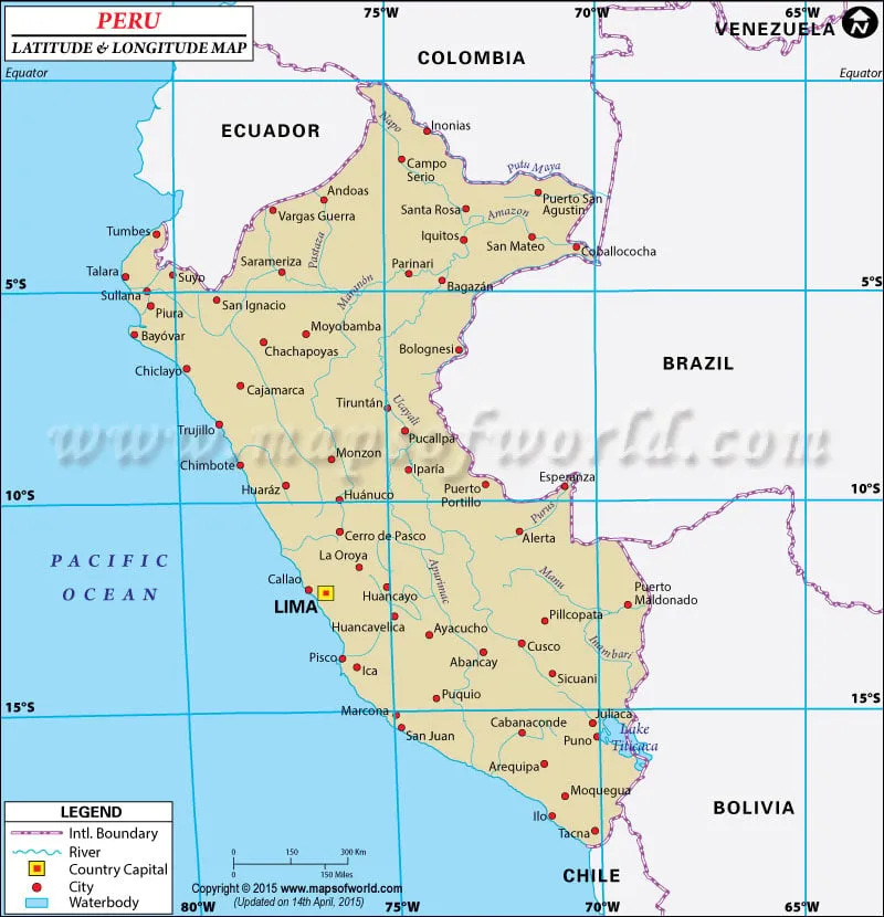
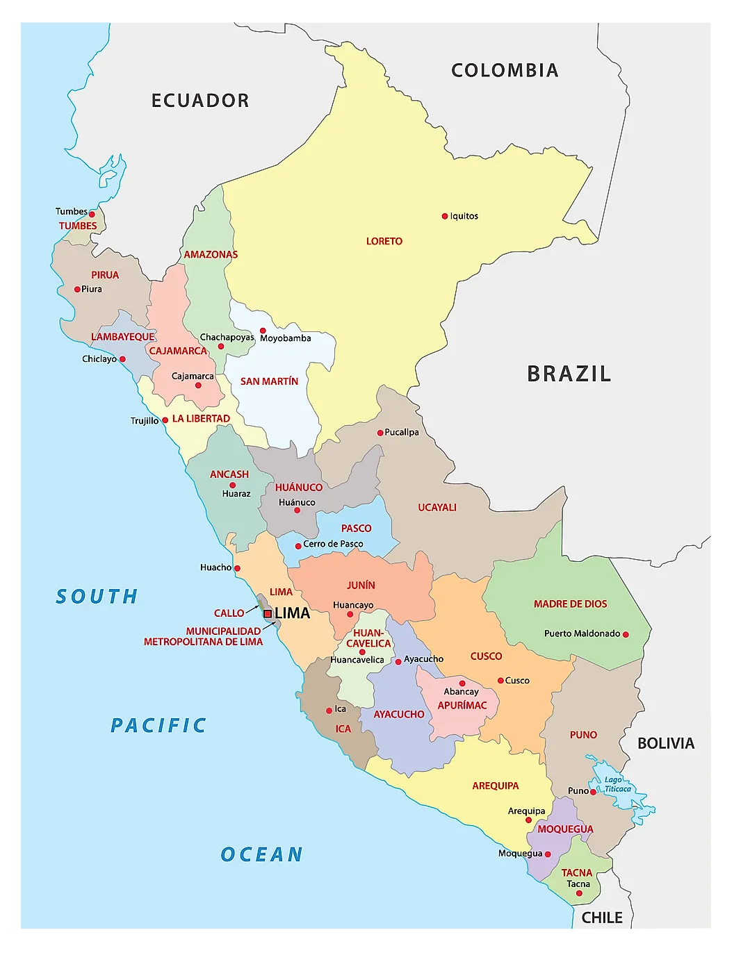
In my assessment, Peru offers the best location for a refuge in South America. If I was going to be in South America, I would explore the highlands from the region of Cajamarca in the north to the Cordillera Blanca in the Ancash region to the south, for possibilities (at approximately 7-9° south latitude). This section of the Andes is the furthest from volcanic zones, situated in the middle, between the Ecuadorian volcanoes to the north and the Southern Peruvian volcanoes to the south. While this area is also supposed to be less seismic compared to the rest of the Andes, a closer examination would be required as there is a Cordillera Blanca Fault Zone. There should be plenty of good water, as Ancash has hundreds of tropical glaciers:
The Cordillera Blanca (Spanish for "white range") is a mountain range in Peru that is part of the larger Andes range and extends for 200 kilometres (124 mi) between 8°08' and 9°58'S and 77°00' and 77°52'W, in a northwesterly direction.[1] It includes several peaks over 6,000 metres (19,690 ft) high and 722 individual glaciers.[1] The highest mountain in Peru, Huascarán, at 6,768 metres (22,205 ft) high, is located there.[1][2]
The Cordillera Blanca lies in the Ancash region and runs parallel to the Santa River valley (also called Callejón de Huaylas in its upper and midsections) on the west. Huascarán National Park, established in 1975, encompasses almost the entire range of the Cordillera Blanca.
Cajamarca is the most important dairy and cheese-making region in the country of Peru. Because of the high soil fertility requirements to raise a productive herd of dairy animals, dairy animals are a good indicator of quality farmland. I also consider meat and milk production as probably the best food production option (in most circumstances) for surviving the cataclysm. I expect that animal foods will be more reliable than plant crops because crop failures are expected to occur with a weakening of the magnetic field strength of the planet.
“In the course of biological evolution, the fossil record tells us mass extinction occurred several times. One working hypothesis to explain such mass extinctions is the cessation of the GMF [geomagnetic field] when the geomagnetic pole was reversed. Because the strength of the GMF is strongly reduced during polarity transitions, when compared to stable normal or reversed polarities, we recently propose that these variations might be correlated to plant evolution.”
(Source: Magnetic field effects on plant growth, development, and evolution)
With a drop in the Earth’s magnetic field, we can expect more crop failures.
Before selecting an exact spot, a closer inspection is required. Things I would investigate include researching the pollution from mining, the population density, getting a feel for the social culture, verifying the purity and reliability of water supplies, finding the right elevation for living year round (I would look for a place at 2,500 meters or higher at the base of a mountain with caves to climb up into). I would choose a spot without without visible cell towers and with no cellphone reception. Because Northern Peru is close to the tropical equator, it is more comfortable to live at higher elevations compared to areas of similar elevation with much greater latitude from the Equator.
Closing comments
One unique risk to South America is the South Atlantic Anomaly.
“Earth’s magnetic field acts like a protective shield around the planet, repelling and trapping charged particles from the Sun. But over South America and the southern Atlantic Ocean, an unusually weak spot in the field – called the South Atlantic Anomaly, or SAA – allows these particles to dip closer to the surface than normal. Particle radiation in this region can knock out onboard computers and interfere with the data collection of satellites that pass through it…
Currently, the SAA creates no visible impacts on daily life on the surface. However, recent observations and forecasts show that the region is expanding westward and continuing to weaken in intensity. It is also splitting – recent data shows the anomaly’s valley, or region of minimum field strength, has split into two lobes, creating additional challenges for satellite missions…
…the SAA is slowly but steadily drifting in a northwesterly direction.”
(Source: NASA Researchers Track Slowly Splitting ‘Dent’ in Earth’s Magnetic Field)
The area underneath the South Atlantic Anomaly may be subject to a higher rate of extinction (or perhaps evolution), due to increased radiation exposures. Whether or not this risk exceeds the dangers more prominent in North America can be difficult to judge. The higher potential for nuclear war, the much greater dependence of the population on a technological food system that is doomed to fail, or the resources and technology readily available to the elite in North America to poison and depopulate humanity, may be a greater danger than the SAA.
I have not encountered a pole flip prediction that I consider to be backed by physical evidence and I therefore did not include this as a factor in my assessment. If it could be determined how the Earth’s poles would likely shift in the next cataclysm, this would be the first and most important criteria in determining a survival location. Adequate elevation is the second most important criteria for site selection.
Egyptian, Vedic, Zoroastrian, Hebrew, and many indigenous stories suggest that many types of natural disasters occur during a cataclysm. There are accounts describing crazy electrical storms, hurricane winds, massive hail, fire storms, freezing, impactors from space and intense solar radiation. Preparations for these types of disasters involve seeking shelter in a cave or underground. I plan to treat the topic of proper onsite shelter more thoroughly at a later date. For some accounts of prior cataclysms, see my article: Warnings from our Ancestors.
Read more of the…
CATASTROPHISM SERIES
More Problems with the 90° Earth Flip Theory
How Will South America Fare During the Next Cataclysm? (this article)





The Andes rising dramatically is congruent with mariobuildreps pole motion derived from ancient monument orientations, where the earth expands in the Pacific region and pressures/squeezes the Atlantic ridges. Causing the axis/pole to shift as the pacific grows.
Good article, I appreciate it. A few thoughts I had though, were centered on the reality of geoengineering, and how that appears to be causing the drought in South America/Amazon at large. They dry out the western coasts, and flood the eastern ones. (worldwide) "We will own the air by 2025" US Air Force. I just recently found out that Ecuador is the only country in all of South America that is experiencing black outs. Due to poor planning regarding infrastructure, and priorities. But it seems to me that despite other countries having back up for water/electricity, geoengineering will take it's toll in all countries, eventually. And I wouldn't discount the biblical story in all of this as well. We are in the end of days....which has a happy ending.....but not on this planet. The earth is groaning for her redemption, just as we all are. Blessings.